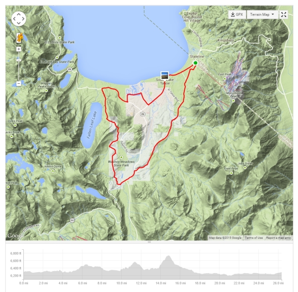
Tour of Lake Tahoe – Stage 4. Click map to see full map and ride stats on Strava.
The marquis ride of every spring break in Lake Tahoe is the “Ride Around the Lake”, and I looked forward to it even more this year after just having my newly rebuilt LOOK 585 with Dura Ace 11-speed components and wheelset. It was a gorgeous day under gorgeous skies, with temps a little coolish (upper 40s) starting out but warming up nicely to the upper 50s during the day with high, thin clouds and winds not too bad.
This is my fourth circumnavigation of Lake Tahoe and third time solo (you can read about my first solo trip here), so I know the route well enough to be comfortable no matter where I am. The first time I rode around the lake (as part of a group) we went counterclockwise—I’m not sure what the rationale was, but on my subsequent solo trips I’ve gone clockwise. This accomplishes two things: 1) it keeps me lakeside so I can safely stop for the many photo opps that present themselves, and 2) it helps me stay a little further away from any potential rockslides that could be a problem if I was riding mountainside (in my previous trip I narrowly escaped a small avalanche at Emerald Bay—had I not been lakeside it might have turned out badly!).
I stopped perhaps a dozen times to take photos and refuel (carried all of my food with me this time). The photos below give a good flavor of what riding around Lake Tahoe is like.

Beginning the ride around Lake Tahoe after leaving South Lake Tahoe, California.
The first views of the lake after leaving S Lake Tahoe are near the base of Mt. Tallac—one of several peaks surrounding the incredible Emerald Bay.
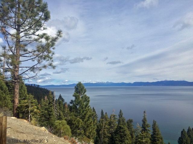
First lake view on ride near the base of Mt. Tallac.
The first climb of the day is actually up the side and then along the spine of a lateral glacial moraine situated between Emerald Bay to the right and Cascade Lake to the left—both left over from the glaciers that scoured the area in the last ice age.

Lateral glacial moraine between Emerald Bay (R) and Cascade Lake.
Nothing compares with the beauty of Emerald Bay and the iconic Fannette Island!

Emerald Bay scenic overlook.
Emerald Bay is the deepest of the southwestern glacial scours, allowing water at the current Lake Level to connect with the Bay (in past millennia lake levels have been as much as 1,000 ft higher than today’s level!). Fannette Island is a small core of granite within the scour that resisted the scouring action of the glacier, poking above the current water level as Lake Tahoe’s only island.

Emerald Bay and Fannette Island.
Heading north from Emerald Bay one encounters the most diverse area of coniferous forest around the lake due to its nice stands of sugar pine (Pinus lambertiana). These pines are the among the tallest of all pines in the world and also bear the longest cones of any pine species. They need moister conditions than other pines, and the western shore offers these conditions compared to the drier eastern shore in Nevada, thus the pines are most common in this part of Lake Tahoe. I never tire of seeing their ragged upper crowns soaring into the skies above and in defiant contrast to the symmetrical crowns of the conifers that dominate the area—Jeffrey pine (Pinus jeffreyi), white fir (Abies concolor), and incense cedar (Calocedrus decurrens), their long, pendulous cones hanging from the tips of their upper branches.
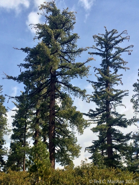
Sugar pines (Pinus lambertiana) at D. L. Bliss State Park, California.
A long, fun descent along the gently sloping, winding, and wildly scenic Hwy 89 leads to a stretch of lakeside riding along the west shore that eventually leads to Tahoe City at the northwest corner of the lake. Riding this stretch I was approaching the halfway point of the ride and needed to refuel. What better place to do so than along the serene rocky west shore at Idlewild?

Lake shore lunch stop at Idlewild, California.
Riding to the east along the north shore and just before crossing the border from California into Nevada, I encountered Kings Beach State Recreation Area. I have passed by this beach many times and never stopped, so this time I decided to take a look. I’m glad I did, as next to the sandy beach is a rock area filled with magical rockpiles that have been meticulously built by countless visitors to the beach. Standing like little gnomes amidst a the backdrop of peaks on the southern shore, they are vulnerable to the vagaries of wind and ill-behaved vandals, yet somehow persist.
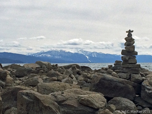
One of the rockpiles that can be found at Kings Beach, California.
In contrast to the gentle slopes on the south, west and north shores, the east shore is steep and rugged, dropping precipitously into the water’s depths at several points of interest. My favorite is Sand Harbor a few miles south of Incline Village. I’ve learned to skip the main park area with its sandy beach and stop instead at a point about a half-mile north of the beach where the jagged, boulder-strewn shoreline results in incredible shades of blue as the water depth changes dramatically. Here, stunning views can be found, along with the solitude that allow them to be sipped and savored.

View from point just N of Sand Harbor.
While I was on north shore I saw that I was carrying an 18.5 mph average—on pace to beat 4 hours if I continued at that pace (something I’ve not accomplished yet), and by the time I left Sand Harbor I was still in the a few tenths above 18 flat. The up-and-down riding along the east shore, however, isn’t conducive to speed and features the biggest climb of the day up to Spooner Lake. It’s not a hard climb, however, and having done it already a few days ago I knew the grade and distance well enough to optimize my gearing at the outset and get to the top with an average just under 18. If I could get it back over 18 I would be gold to beat 4 hours. I blasted down the descent along Hwy 50—filled with fresh descending mojo from the last several days of riding in the mountains and entered the last 10-mile rolling stretch that leads back into South Lake Tahoe. A few miles from town I encountered Cave Rock, where a tunnel blasted through the rock presents a risk of conflict between any bikes and cars that should happen to find themselves together inside the tunnel. A button emplores cyclists to press a button that turns on warning lights for motorists (assuming they are inclined to pay heed to such), but the stop to do such could put my sub-4 hour goal in jeopardy. Should I stop and press the button, or should I blast through? Ah well, sensible me won out (and good thing it did, as a car ended up overtaking me before I got through the tunnel).

Cyclist light at Cave Rock.
By that point, and with only a few small climbs ahead of me, my average speed had climbed well above 18 mph and was still on the rise as I reached the outskirts of town—I knew I had it! I had just ridden around Lake Tahoe solo in under 4 hours. If you think that is so-so accomplishment, well guess what? I’m closing in on 60 years old, bitches!

Ride around Lake Tahoe stats.
Stage 4 covered 72.4 miles with 4,593 ft of climbing in 3:54:14 (avg speed 18.5 mph), bringing the combined Stages 1–4 totals to 194.0 miles, 11:01:43 (avg 17.6 mph), and 15,233 ft of ascent. Tomorrow’s ride (Stage 5) will be another short one to recover from today’s ride and freshen the legs up for Stage 6—the “Queen” stage! Despite its relatively short distance, I do a little bit of climbing and discover some gem roads that I didn’t know about despite the amount of riding I’ve done here in the past.
© Ted C. MacRae 2015